

.avif)
Introducing Geospatial Data
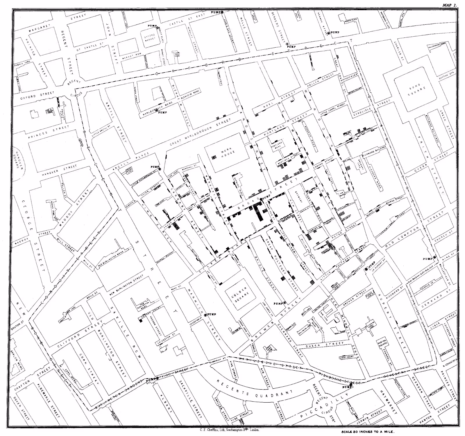
In 1854, John Snow famously used geospatial data to discover the source of a cholera outbreak that was wreaking havoc on the streets of London. By mapping out the specific locations where people were getting sick, he was able to link the illness to a specific water pump in the city – and stop further spread of disease.
Today, more complex forms of geospatial data analysis are used for everything from environmental monitoring to urban planning. And in the business world, location intelligence gleaned from geospatial data is used to conduct market research, optimize decision-making, and improve return on investment (ROI).
But what exactly is geospatial data and what makes it unique? Read on to learn all about geospatial data and how it can be used to optimize your business. Some of the topics that will be covered in this article include:
- The definition of geospatial data and some common examples.
- The difference between vector data and raster data.
- Concrete ways to leverage geospatial data to optimize business operations.
- How different types of geospatial data can be combined to paint a comprehensive picture of consumer activity and demand in a given area.
- Tools that make it easy to derive actionable insights from geospatial data.
What is Geospatial Data?
Simply put, geospatial data is any information that is tied to a specific geographic location. Geospatial data can be displayed on a map (more on that below), but it doesn’t have to be – the term “geospatial data” refers to any data or information that has a geographic component.
Examples of Geospatial Data
Common examples of geospatial data include:
- The geographical coordinates of relevant points of interest (POIs), their addresses, and other identifying details.
- User reviews for specific restaurant venues, retail establishments, and other attractions.
- Information about local weather patterns.
- Topographical information, including the locations of bodies of water, landforms, mountain ranges, and other natural phenomena.
- Foot traffic analytics, which provide insight into visitation patterns to specific POIs.
- Location-specific demographic and psychographic metrics – including census data on a given population’s age and income distribution, and other private and public datasets that shed light on a population’s shopping habits and consumer preferences. Location-tagged social media activity (geosocial data) is also a form of geospatial data that provides insight into consumer behavior.
- Information on area attributes like crime rates, construction projects, and development plans.
- Data on local businesses and potential competition.
Collecting Geospatial Data
There are as many methods for collecting geospatial data as there are kinds of data. The precise geographic coordinates of specific POIs and locations are often obtained using satellite-based GPS technology. Topographical information and other details about the Earth’s surface are gathered with the help of satellite imagery and ground surveys. Foot traffic analytics are usually derived from data collected from mobile devices – stripped of personal identifiers like names and MAIDs and aggregated to yield statistical information about how people move in the physical world. And location-specific demographic and psychographic data is collected and analyzed by the Census Bureau – as well as a variety of private companies – each employing their own methodology.
Geospatial Data Visualization: Raster Data and Vector Data
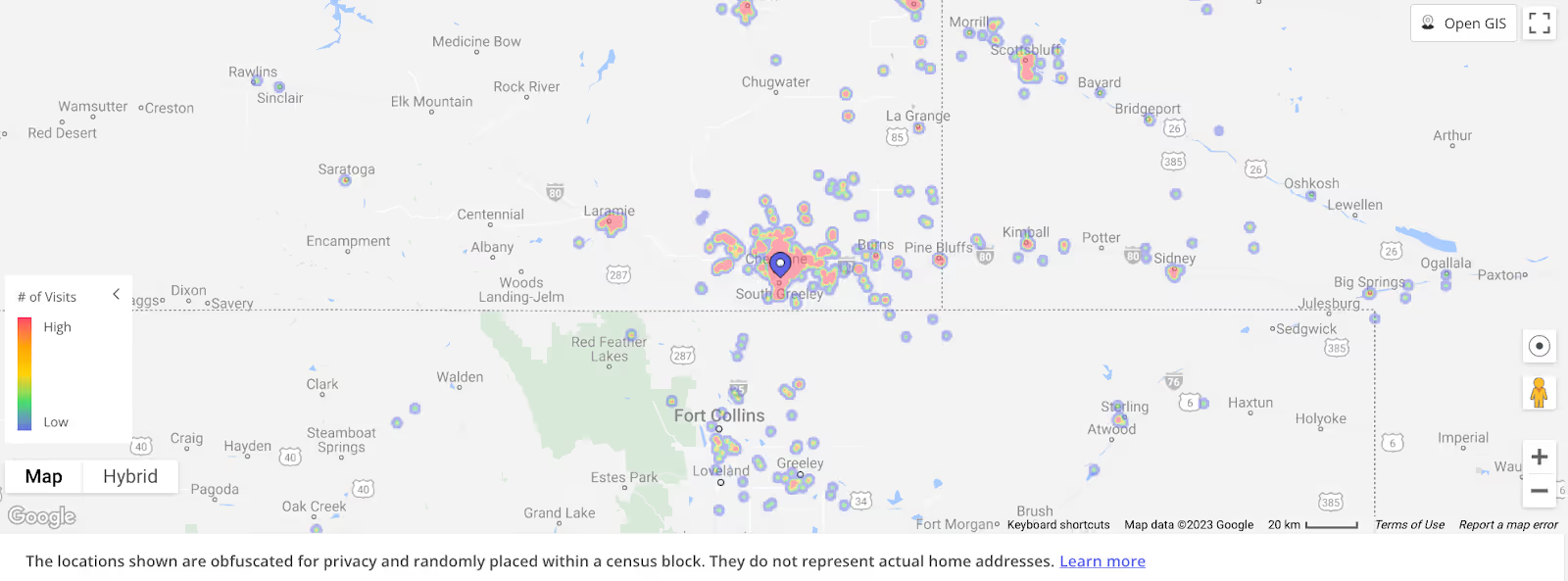
Visualizing geospatial data on a map can make it much easier to understand the relationships between different data points – allowing insights to be derived that would be hard to glean from merely analyzing tables of data.
Often, geospatial data mapping is conducted with the help of a Geographic Information System (GIS) – a computerized tool that integrates multiple layers of information on a digital map. In this context, it is common to distinguish between two types of geospatial data: vector data and raster data. Vector data uses geometric representations like points, lines, and polygons to show different locations and the mathematical relationships between them. Raster data, on the other hand, takes the form of pixels or cells. Digital satellite imagery is a kind of raster data.
How Geospatial Data is Used: 4 Business Use Case Examples
Geospatial data also includes a wide variety of metrics connected to physical stores, dining venues, shopping centers, and other brick-and-mortar businesses. One of the most important of these is foot traffic data, which offers visibility into visit patterns at given locations.
In this section we’ll delve into some of the concrete ways that foot traffic data can be combined with other location-based datasets to glean actionable insights across industries.
1. Leveraging Geospatial Data to Optimize Retail Operations
Geospatial data is critical to almost every stage of running a brick-and-mortar retail business – from choosing the best location for a new store to optimizing the pricing strategy and deciding which items to stock.
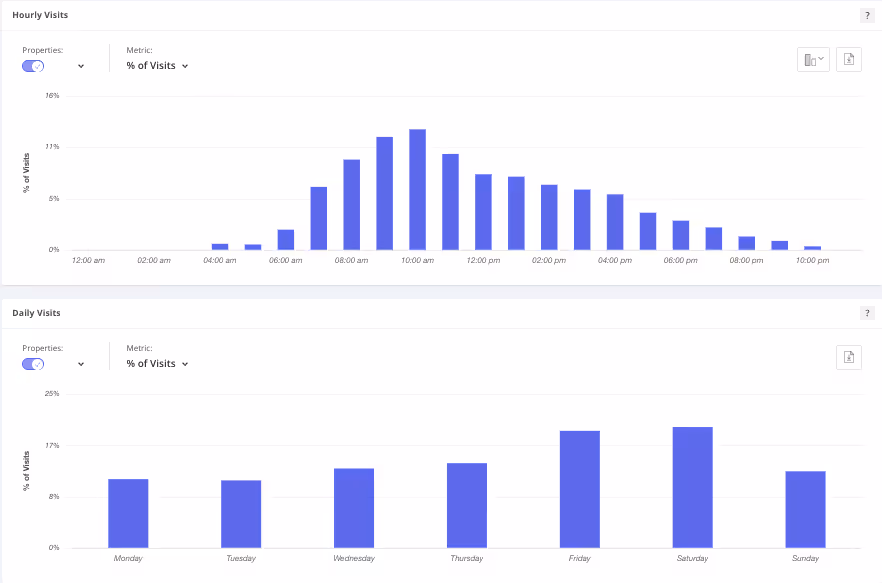
By analyzing store- or chain-specific foot traffic trends – both of which are considered geospatial data by virtue of being tied to specific geographic locations – retailers can quickly and efficiently determine the number of daily, weekly, or monthly visits and unique visitors to their venues. Foot traffic data can reveal hourly breakdowns that show when a store is likely to be the busiest and help retailers identify seasonal peaks and downturns. And by monitoring visit patterns over time, store owners and managers can track a venue’s performance and keep their fingers on the pulse of what’s working – and what’s not.
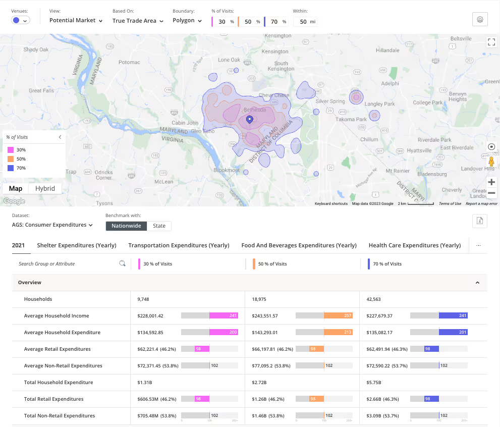
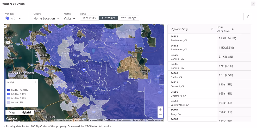
Foot traffic data and other geospatial data sets can also be combined in different ways to reveal deeper insights. Visit data to different POIs or chains can be joined to reveal cross-shopping habits and other consumer behaviors. And foot traffic data can be layered with location-based demographic and psychographic metrics – additional forms of geospatial data – to analyze consumer profiles in stores’ true trade areas.
All of these kinds of geospatial data analyses can be conducted at various levels: within individual stores, between stores belonging to the same chain, or across brands, regions, and industries. Retailers can analyze their own stores or those of competitors – allowing them to stay on top of the competitive landscape and identify trends as they begin to emerge.
2. Harnessing Geospatial Data to Operate and Use Retail Media Networks
Geospatial data is also crucial for allowing retailers to capitalize on the growing retail media network opportunity, through which retailers can utilize their physical footprints to generate advertising revenue. Physical visits are for in-store advertisements what ad impressions are for websites – so gaining visibility into a store or group of stores' visitor base and visitation metrics allows retailers to attract the right advertisers and optimize their partners’ campaigns.
Retailers can use foot traffic data, combined with additional geospatial datasets (i.e., datasets connected to a physical space), to identify the preferences and characteristics of a store's captured market and to determine peak visitation times for different audience segments. Potential advertisers can also use retail foot traffic data to track visitation patterns at different chains and hone in on the retail media networks most suitable for their offerings.
3. Evaluating Commercial Real Estate Opportunities with Geospatial Data
Real estate professionals also rely on geospatial data to analyze investment opportunities, manage risks, and optimize the operations of commercial properties.
Imagine a commercial real estate (CRE) investor that is considering the purchase of a shopping center. In addition to traditional metrics like occupancy rates and rental fees, he or she will need a variety of geospatial data points – location-based metrics connected to the venue at hand and its surrounding area – to assess the center’s health and the investment’s potential ROI.
Some of the geospatial data points that the investor will want to consider include foot traffic patterns to the center as a whole and to its individual stores; demographic and psychographic data regarding the center’s true trade area; local crime statistics, development plans, and transportation infrastructure; and more.
4. Utilizing Geospatial Insights to Secure Financing for a New Restaurant
Geospatial data can also be key to helping new businesses secure the financing they need to get off the ground.
Take the example of a chef that has decided to open a new restaurant and has chosen a tentative location for the venue. By using foot traffic data combined with other geospatial datasets, he or she can determine the restaurant’s predicted true trade area and analyze consumer demand – and make a strong case for the venue’s future success.
Geospatial Data Tools
To unlock the potential of geospatial data analytics, businesses need solutions that allow them to quickly gather, integrate, and analyze vast quantities of information and easily layer multiple datasets on top of one another. And perhaps most importantly, they need accurate and up-to-date foot traffic data on which to base their analyses. Location intelligence platforms that combine geospatial data visualization with other forms of advanced geospatial data analytics allow users to leverage the full potential of geospatial data to obtain relevant insights.
Placer.ai’s Integrated Geospatial Data Solution
This is where Placer.ai comes in. Placer.ai’s easy-to-use location intelligence platform provides businesses with the integrative tools they need to effectively utilize geospatial data.
The foundation of Placer’s platform – constructed with a privacy-by-design approach – is accurate, comprehensive location analytics that are extrapolated using AI and advanced data models – providing customers with unprecedented visibility into consumer foot traffic trends nationwide.
Placer’s Data Marketplace
And foot traffic data is just the beginning. Using Placer’s Marketplace, retailers, commercial real estate brokers, civic stakeholders and others can effortlessly layer a host of other geospatial datasets on top of the visitation data to conduct complex analyses with the click of a button. Placer’s Marketplace includes more than 20 geospatial datasets that can be seamlessly integrated and used with its platform, including (among many others):
- Placer’s Migration Trends Report, which allows users to explore population changes at the state, county, CBSA or zip code level.
- Spatial.ai’s PersonaLive, which combines store visitation with geosocial data to classify households into 80 different segments based on behavioral and demographic traits.
- Applied Geographic Solutions’ (AGS) datasets, including Behavior and Attitudes, Consumer Expenditures.
- STI’s Popstats, which offers demographic insights and future population growth forecasts.
- Experian’s Mosaic, which segments consumers according to behavioral and demographic characteristics.
- Census data.
- AGS’ CrimeRisk and Environment datasets, which provide details on weather and crime risks across areas of interest.
- Niche’s Neighborhood Grades dataset, which provides an assessment of the livability of any US neighborhood.
- STI’s Market Outlook, which analyzes data from multiple sources to provide estimates of retail supply and unmet demand for dozens of different product and business categories.
- AGS’ Retail Potential/Gap, which estimates consumer gaps and surpluses across categories.
In addition to a highly intuitive and user-friendly UI, Placer.ai offers a geospatial data API that can be customized and integrated with internal or third-party applications.
Final Thoughts
Location intelligence derived from accurate, up-to-date, and comprehensive geospatial data has become key to decision-making across many industries.
In this piece, we discussed some key geospatial data types, and some of the ways they can be harnessed to drive business success. For more use cases and examples of how location intelligence can fuel growth in fields from commercial real estate to municipal economic development, check out our Guides section.

